| A Guide to the science of the atmosphere | |||||
|
|
|||||
|
|||||
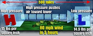
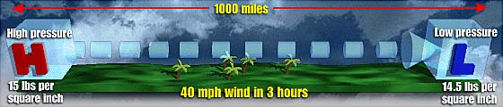
| Source: The USA TODAY Weather Book, second edition Graphic by Kevin A. Kepple What's happening inside highs and lows By Jack Williams, USATODAY.com
The weather maps, such as those on television, show what's happening at the Earth's surface, and that's what we're talking about here. As the name says, a "high" is an area where the air's pressure is higher than the pressure of the surrounding air. A "low' is where it's lower. Meteorologists don't have any particular number that divides high from low pressure; it's the relative differences that count. The pressure is high at the surface where air is slowly descending - much to slowly to feel. And, this is going on over a large area, maybe a few hundred square miles. As air descends, it warms, which inhibits the formation of clouds. This is why high pressure is generally - but not quite always - associated with good weather. The air that descends in high pressure areas, has to get to high altitudes in some way, and that way is by rising in areas where the pressure at the surface is low. As air rises it cools. As the air cools, the humidity in it begins to condense into tiny drops of water, or if it's cold enough, into tiny ice crystals. If there is enough water, or ice, rain or snow begin to fall. This is why low pressure is associated with bad weather. As shown in the graphic above, the air descending in high pressure flows out in a clockwise spiral in the Northern Hemisphere. Air flowing into an area of low pressure to rise, makes a counterclockwise spiral on the way in. For more on why the wind flows in the directions it does, you could go to the USATODAY.com Guide to the science of the atmosphere and look at the links from the section on "The what and why of the wind." Probably a better way to learn, however, is to look into some of the books we recommend. |
|||||
|
|
|||||
 |
|||||
 |
|||||
|